Real-time monitoring scheme of environmental groundwater - multi-parameter can be customized
1. Why do we need to do groundwater monitoring?
In recent years, with the continuous development of natural resources by human beings, ecological problems such as the decline of groundwater level, land subsidence, and water quality deterioration have been caused. At the same time, the discharge of industrial sewage and domestic sewage also has an impact on groundwater, which in turn affects the health safety of human beings and the stability of natural ecosystems. In addition, groundwater is the basic material for the survival of industry and agriculture. According to surveys, groundwater provides 40% of the world's water for agricultural irrigation and 30% of industrial water! Therefore, real-time monitoring of groundwater is an important means to grasp the law of groundwater changes, understand the status of groundwater exploitation, and guide the protection of groundwater resources.
2. What indicators are monitored for groundwater monitoring?
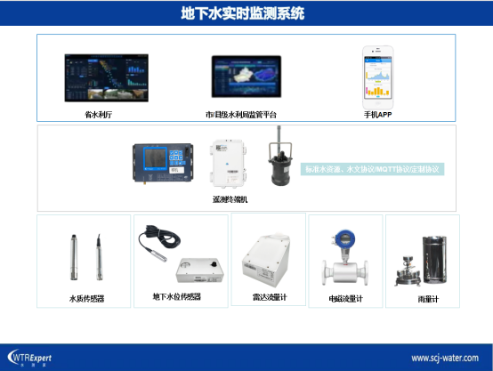
The groundwater monitoring system is composed of groundwater automatic monitoring station monitoring equipment and monitoring center platform software. The monitoring equipment automatically collects and stores groundwater level, water temperature, water quantity, and water quality data, and regularly reports it to the provincial/municipal/county-level monitoring center platform through the 4G/NB-IoT/Beidou wireless communication network, which automatically receives and stores the data, and conducts dynamic analysis of groundwater change laws.
Three-system composition

Fourth, the advantages of the system:
Passed the water conservancy industry standard inspection: "Hydrological Monitoring Data Communication Protocol (SL651-2014)"
Mature docking with the groundwater monitoring platform of various provinces
4G/NB/LOT/Beidou satellite communication mode is optional and adapts to local communication conditions;
It can report to 1-4 central stations at the same time to meet the needs of county, municipal, provincial and national multi-level management
The products are designed with ultra-low power consumption, and the battery life is longer
IP68 protection level, waterproof, moisture-proof, rain-proof, anti-soaking, open worry-free working mode
The collection cycle can be flexibly set according to customer needs
Flexible customization of products according to customer needs
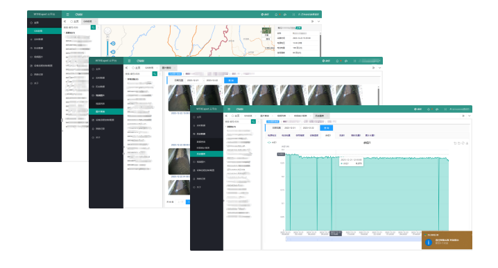
Wu data cloud platform
GIS Overview: Vector map displays the distribution location, alarm status and single-point monitoring data of measurement points
Real-time data query: display the latest water level data, battery voltage, device status, signal quality, etc
Historical data query (historical report, time period report, hourly report, daily report, historical chart)
Video image (video viewing, image query)
Alarm setting: automatic alarm for water level exceeding the limit, power level is too low, equipment abnormality, etc
Data Statistics: Generate data statistics reports on the hour, day, month, or any time period


